Rochester Embayment Area of Concern
The Rochester Embayment Area of Concern (AOC) is a broad bay on the south shore of Lake Ontario at the mouth of the Genesee River. It is an approximately 35 square mile portion of Lake Ontario between Nine Mile Point in the Town of Webster and Bogus Point in the Town of Parma.
The watershed that drains to the Rochester Embayment includes approximately 3,000 square miles and includes all or parts of ten counties (nine in New York and one in Pennsylvania). In New York, most of the watershed lies within six counties: Allegany, Genesee, Livingston, Monroe, Ontario, and Wyoming.
DEC, U.S. EPA, and Monroe County Department of Public Health Recommend Removal of Rochester Embayment from Areas of Concern
After years of cleanup and restoration efforts, environmental monitoring shows the removal criteria established to remove beneficial use impairment designations and delist the AOC have been met. There will be a public input session with a brief presentation and the public can ask questions and submit comments about the delisting report and process.
Public Input Session:
July 9, 2024 5 to 7pm
Central Library of Rochester's Kate Gleason Auditorium
115 South Avenue, Rochester, NY 14604
Note: Parking is available on the street or the adjacent parking garage. The library is also on the city's bus route.
In addition to the public input session, there is a 30-day public comment period opening July 1 and ending July 30, 2024. Mail comments to: Jim Lehnen, Environmental Program Specialist, DEC / Great Lakes Program 700 Delaware Avenue, Buffalo, NY 14209. Or email your comments to: [email protected] with “Rochester AOC Delisting” in the subject line. All comments must include the person’s full name, affiliation or organization, email address, physical address, and town of residence.
The delisting report will be added to the following link by the July 1st comment period start:
Rochester Embayment Area of Concern Delisting Report
See the full press release on the delisting here.
Recent Beneficial Use Impairment (BUI) Removal Reports (Note: all 14 BUIs have been removed!)
- Rochester Loss of FW Habitat BUI Removal Report(September 2023)
- Bird or Animal Deformities or Reproductive Problems BUI Removal Report (September 2022)
- Degradation of Aesthetics BUI Removal Report (June 2022)
For access to older BUI reports and other AOC documents, please visit the H2O Hero Page!
Additional Links
- USGS Streamflow Gauging Stations in Monroe County
- Survey of Lake Ontario Bottom Sediment off Rochester
- Watershed Article, Winter 2001-2002
Sub-Basins That Drain To the Rochester Embayment
Drainage into the Rochester Embayment comes from three major sub-basins: The Genesee River Sub-Basin, the Lake Ontario Central Sub-Basin and the Lake Ontario West Sub-Basin.
Download the Rochester Embayment Three Major Sub-Basins Map (150k PDF).
The Lake Ontario West Sub-Basin is the 309 square mile portion of Lake Ontario’s West Basin that drains to the Rochester Embayment. The West Sub-Basin includes parts of Monroe and Orleans Counties. Northrup Creek/Long Pond is a tributary to Lake Ontario within the West Sub-Basin.
- Issue 5: Phosphorus Decreases in Northrup Creek and Long Pond (1,932k PDF)
- Northrup Creek Watershed Map (52k PDF)
- Northrup Creek/Long Pond Watershed Plan (11k PDF)
- Phosphorus Loads Entering Long Pond, A Small Embayment of Lake Ontario near Rochester, New York (708k PDF)
The Lake Ontario Central Sub-Basin is the 224 square mile portion of Lake Ontario’s Central Basin that drains to the Rochester Embayment. The Central Sub-basin includes parts of Monroe and Ontario Counties. Irondequoit Bay is the dominant feature in the Sub-basin. Irondequoit Creek is the major tributary to Irondequoit Bay.
- Allen Creek Near Rochester, Real-Time Water Data
- Irondequoit Creek above Blossom Rd, Real-Time Water Data
- Irondequoit Creek at Empire Blvd., Real-Time Water Data
- Learn more about Water Resources of MC, Water Years 89-93 in the Irondequoit Creek, Part 2
- Effects of a Cattail Wetland on Water Quality of Irondequoit Creek (2,037k PDF)
- Irondequoit Creek Watershed Stormwater Management: Packet for Developers (450k PDF)
- Irondequoit Creek Watershed Map (175k PDF)
- Issue 6: Irondequoit Creek Watershed Gets a Model (1,451k PDF)
- Linear Park Project (Watershed article) (8k PDF)
- Water Resources of Monroe County, Water Years 89-93 in the Irondequoit Creek Part 1 (2,003k PDF)
- Water Resources of Monroe County, Water Years 94-96 in the Irondequoit Creek (505k PDF)
- Irondequoit Creek Wetlands Project (14k PDF)
The Genesee River Sub-Basin is approximately 2,500 square miles in size and drains to the Rochester Embayment. Black Creek, Oatka Creek and Honeoye Creek are among the tributaries to the Genesee River. The Rochester Embayment Remedial Action Plan is the watershed plan for the Rochester Embayment and the Genesee River.
- Genesee River at Ballantyne Bridge Real-Time Water Data
- Map
- Black Creek at Churchville, NY Real -Time Water Data
- Oatka Creek at Garbutt, NY Real-time Water Data
- Honeoye Creek at Honeoye Falls, NY Real-Time Water Data
- Rochester Embayment Remedial Action Plan
- Black Creek Watershed Coalition
- Black Creek Watershed Map (251k PDF)
- Issue 2: Long Term Data Show Water-Quality Improvement in the Genesee River (1,423k PDF)
- Issue 7: Improving WQ in MC - The Oatka Creek Watershed Committee (1,386k PDF)
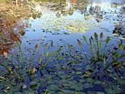 Wetlands
Wetlands are transitional areas between open water (lakes, rivers, etc.) and dry land. Some wetlands are easy to identify because they contain distinctive plants such as cattails, rushes, and reeds. Wetlands are important natural resources because they provide many valuable functions including water quality protection, flood and erosion control, and fish and wildlife habitat. A number of local programs are underway to conserve these resources.
- Do Created Wetlands Replace the Wetlands that are Destroyed? (596k PDF)
- Issue 4: Wetland Study Enters Second Phase (58k PDF)
- Wetlands for Citizens and Land Use Decision Makers pamphlet (550k PDF)
Watershed Maps
Basin, sub-basin and watershed are all terms that identify an area of land that drains to a particular waterway. We often prefer the term watershed for the drainage area of a creek. Refer to the Monroe County Watershed Map if you would like to find out which watershed you live in.
- Monroe County Watershed Map (8.7mb PDF)
There are 13 gauging stations in Monroe County that collect data on streamflow. The below map shows their locations:
Stormwater Management
Stormwater is the runoff from parking lots, roads, and driveways that enters a waterway (such as a stream, river, or lake) during a rain storm or snow melt. Both local and national research indicates that stormwater runoff is a primary source of pollutants to our local water resources. Many local programs are being implemented to address the water quality impacts of stormwater runoff.
Visit the Environmental Protection Agency Stormwater website.
- Effects of a Vegetated Stormwater-Detention Basin on Chemical Quality and Temperature of Runoff from a Small Residential Development in Monroe County, NY (2,646k PDF)
- Issue 3: Allen Creek Stormwater-Management Facility a Success (903k PDF)
- Overview Stormwater Management (7k PDF)
- Stormwater Coalition Intermunicipal Agreement (12k PDF)
- Stormwater Coalition Update (9k PDF)