County Office Building
39 W. Main St. - Suite 304J
Rochester, NY 14614
Daniel J. Holtje, PLS
County Surveyor
Phone: 585 753-1156
Fax: 585 753-1192
[email protected]
Welcome
The Monroe County Survey Office maintains nearly 5,700 geodetic survey monuments and the right of way records for 650 miles of County highway. The network of monuments forms a base survey to aid in the orderly growth of the community. When properly used as reference, the network reduces land measurement inconsistencies. Rules and regulations for the use and protection of the survey network are set forth in Local Law No. 6 of 2019, the authority for which rests entirely with the Monroe County Legislature.
The Monroe County Surveyors Office also performs and reviews consultant boundary surveys related to County highway right of way and utility easement acquisitions, and performs County Park boundary surveys and property boundary surveys prepared for real property either sold or acquired by the County of Monroe.
Information For General Public
- Property Instrument Survey Maps - How to Find
- Licensed Land Surveyor - How to Find
- County of Monroe Website
- Interactive Monroe County Parcel Map
- Monroe County Clerk Online Services
- New York State Orthoimagery (Aerial Images)
- New York State Monument Destruction Law
- New York State Surveyor Right of Entry Law
- Monroe County & Municipality Maps
Land Surveyor Resources
Monroe County Monumentation Law
- Monroe County Monumentation Law Local Law No. 6 of 2019
- Introduction of Monroe County Monumentation Law Local Law No. 6 of 2019
- Monroe County Monumentation Law Guide
- Local Accuracy and Network Accuracy Definitions
- Monroe County Monument Webviewer and Tie Sheet Information
- National Geodetic Survey - NGS Monument Webviewer
- Geodetic Monument Standard Preservation Note
- Geodetic Monument Monitoring Requirements
- Example Geodetic Monument Monitoring Report
- Geodetic Monument Positioning Requirements
- Geodetic Monument Installation Requirements & Spec
- Geodetic Monument Installation Multiple Sequence Requirements & Spec
Subdivision Map Review and Filing
- MCSO & Real Property Subdivision Map Requirements
- MCDOT Easement Acquisition Map Requirements For Current Highway Project
- Real Property Subdivision Map Fee Schedule & Filing Requirements
- Phelps & Gorham Purchase By Town
- MCSO & MCDOT Adobe pdf Approval Block (See Below For Autocad Block File
- Subdivision Map Checklist
General and Technical Survey Information
- General Information & Guidelines for Local Survey Community
-
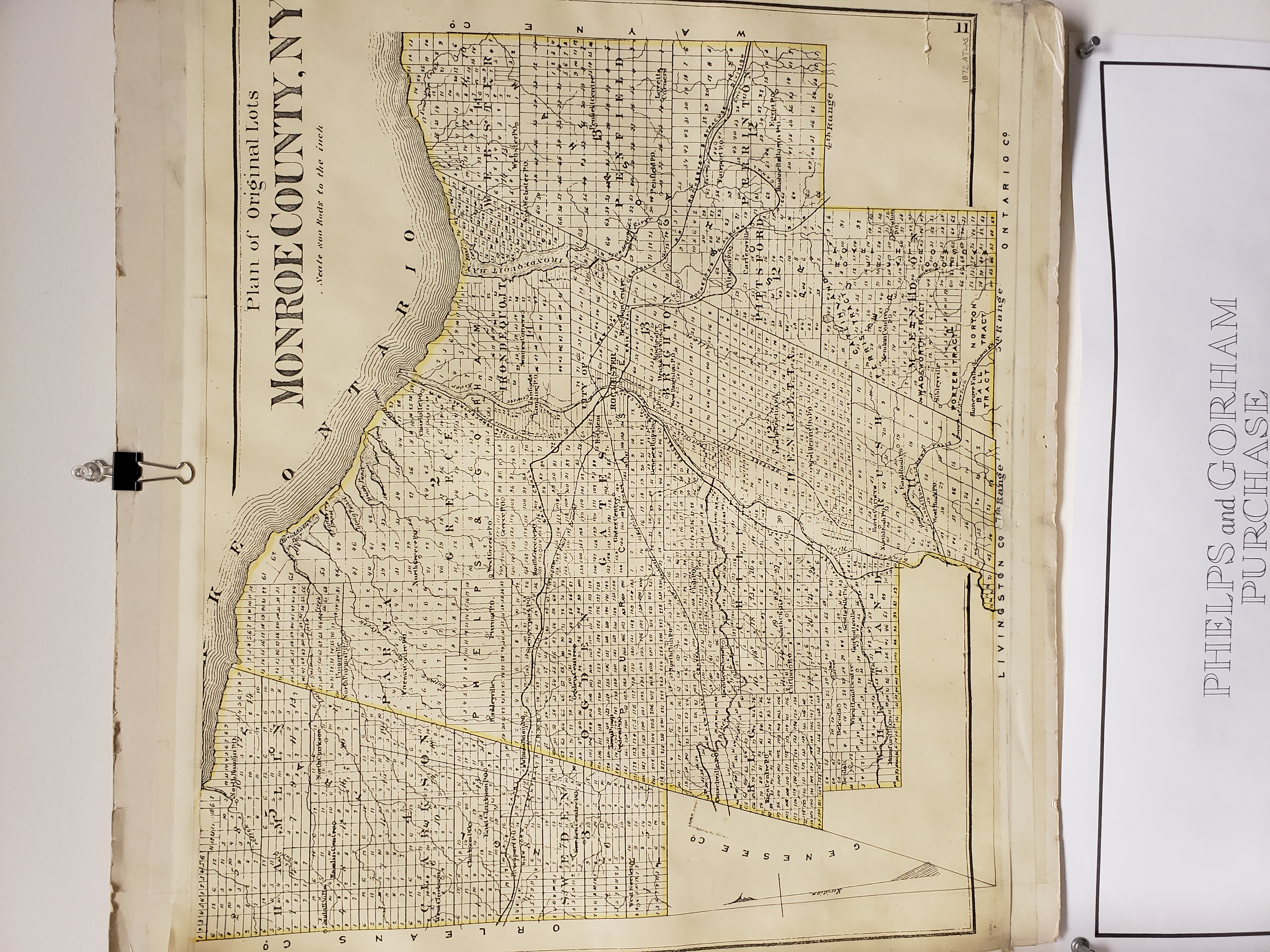
Phelps & Gorham Maps & Information
- Town Chili Historical Summary of Subdivision of Great Lots
- Town Chili Historical Subdivision of Great Lots
- Plan of Original Lots From 1872 Atlas - Monroe County NY
- Phelps & Gorham Purchase Map
- Phelps & Gorham Purchase By Town
- Monroe County Phelps & Gorham Breakdown Summary
- City of Rochester Great Lots Hopkins 1910_Plate 44
- County Record Room Information & Access
- NGS User Guidelines for Single Base Real Time GNSS Positioning
- NSRS22 Datum Jan 2021 NGS Presentation
- NGS Coordinate Conversion & Transformation Tool (NCAT)
- NYS NET (NYS Spatial Reference Network)
- NYSNET Spider Business Center
- MCSO Rochester Calibrated Baseline
- NOAA Publication of Rochester Calibrated Base Line
- MCSO Handout-Have You Checked Your EDM Lately
- Variance in Vertical Datums
- Interactive Monroe County Parcel Map
- Monroe County Clerk Online Services
- New York State Orthoimagery
- NYS ED Professional Engineering & Land Surveying Registration & Eligibility Procedures
- NYS ED Frequently Asked Survey Practice Questions
- Monroe County & Municipality Maps
Monroe County Highway Right of Ways
County Survey Cad & Data Files Available For Download
- County Highway Boundary Plans
- County Highway Permanent Survey Marker Record Sheets
- County Park Boundary Surveys
- County Subdivision and Property Boundary Surveys
- County Utility Easement Surveys
- MCSO & MCDOT Autocad Approval Block
- Geodetic Survey Monument Record Sheet Master Form
- Permanent Survey Marker Record Sheet Master Form
MCDES / MCPW Easement Map Requirements
Survey Standards and Laws
- New York State Education Department 2000 Land Surveying Practice Guidelines
- GVLSA 2017 Local Standards
- NYSAPLS 1997 Code of Practice
- ALTA-NSPS 2021 Survey Requirements
- New York State Monument Destruction Law
- New York State Surveyor Right of Entry Law
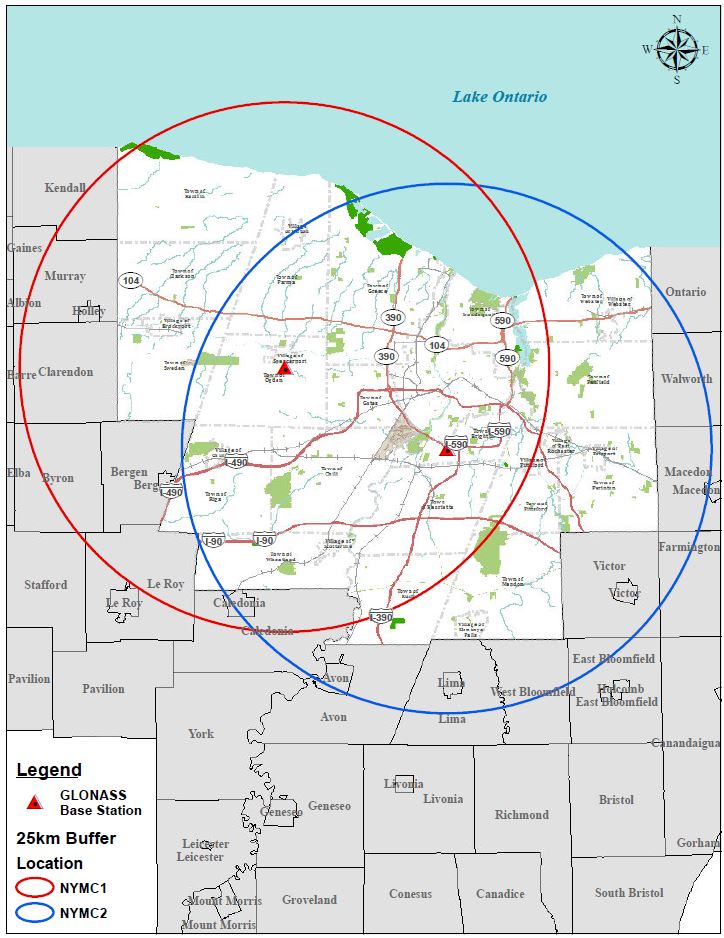
Monroe County GNSS CORS
Available to the public, is the ability to connect to County base stations to perform Real-Time Kinematic (RTK) surveys. Anyone with the appropriate equipment can simply register with our GIS Services Division and receive a username and password to access the base station 24 hours a day, 7 days a week.
GPS Base Data and Access Information
Monroe County GNSS Base Station Map

Dig Safely NY
Be Sure To:
- Call Before You Dig
- Wait The Required Time
- Confirm Utility Response
- Respect The Marks
- Dig With Care
Contact: 800-962-7962
Survey Related Web Sites
US Department of Commerce
New York State Department of Transportation
- NYS NET (NYS Spatial Reference Network)
- NYSNET Spider Business Center
- NYSDOT - Geodetic Control Viewer
- New York State Department of Transportation - Land Surveying Section
New York State Education Department
City of Rochester
Professional Survey Associations
- New York State Association of Professional Land Surveyors (NYSAPLS)
- Genesee Valley Land Surveyors Association (GVLSA)
- American Land Title Association (ALTA)
- National Society of Professional Surveyors (NSPS)
- IRWA - International Right of Way Association


